
David Cole's Metro Cincinnati Plan
The Metro Cincinnati plan began in 2009 as part of an academic requirement in fulfillment of a Master of Architecture degree (Cole n.d. a). The plan is the most comprehensive and detailed one reviewed on this webpage. To be clear, Cole's Metro Cincinnati plan is not related to SORTA's MetroMoves plan.
The Metro Cincinnati plan is truly multi-modal, using three different rail transit technologies to achieve different mobility goals, they include: a heavy-rail transit system, similar to the New York Subway or Washington Metro; a system of light rail lines for local circulation and inter-city commuter travel, and a vast network of local streetcar lines. The lines for rapid transit would run longer distances on a separate right-of-way, while the streetcars would serve as circulators within neighborhoods and as feeders to rapid transit lines (Cole n.d. b). The many other differences between types of rail transit are described on the Types of Rail Transit page. Where possible, the lines also borrow from existing rail right-of-ways and infrastructure, such as: Union Terminal, the Riverfront Transit Center, the planned Oasis Line, etc (Cole n.d. a).
The Metro Cincinnati plan is truly multi-modal, using three different rail transit technologies to achieve different mobility goals, they include: a heavy-rail transit system, similar to the New York Subway or Washington Metro; a system of light rail lines for local circulation and inter-city commuter travel, and a vast network of local streetcar lines. The lines for rapid transit would run longer distances on a separate right-of-way, while the streetcars would serve as circulators within neighborhoods and as feeders to rapid transit lines (Cole n.d. b). The many other differences between types of rail transit are described on the Types of Rail Transit page. Where possible, the lines also borrow from existing rail right-of-ways and infrastructure, such as: Union Terminal, the Riverfront Transit Center, the planned Oasis Line, etc (Cole n.d. a).
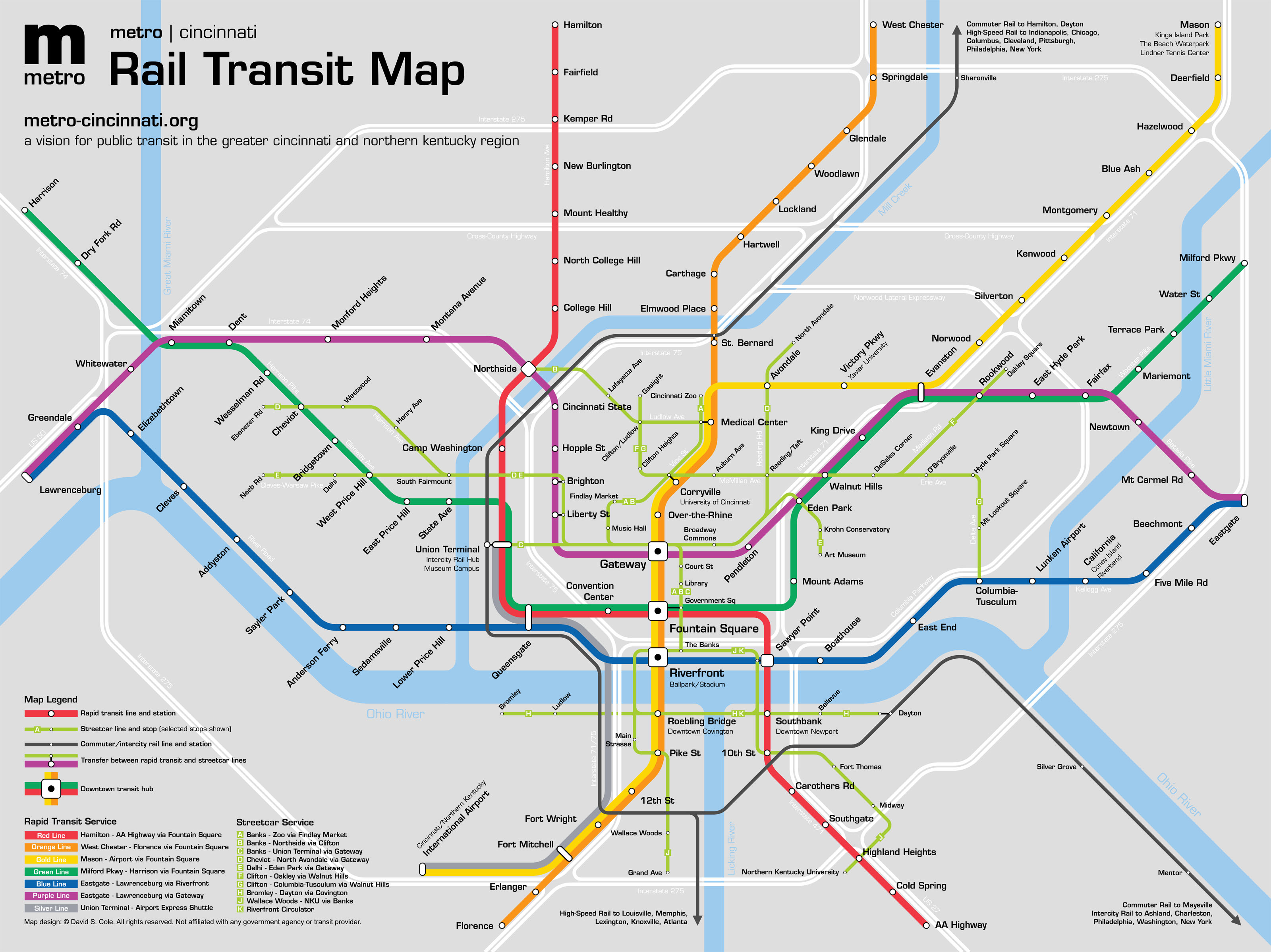
Image source: Cole 2014
How The Plan Moves Through Kentucky
There are a total of four "rapid transit service lines" that would serve Kentucky (Cole n.d. b). Presumably, all four of these lines are light rail lines.
The 'Silver Line' is the only route in the plan that does not move through downtown Cincinnati. Instead, it would act as an Airport express line that would depart from Union Terminal and pass through Fort Wright and Fort Mitchell, using Interstate 75's right of way, and terminate at the Airport. This express line is unique to Metro Cincinnati's plan.
The 'Orange Line' runs all the way from Florence to Westchester; running through Covington, downtown Cincinnati, Uptown, and the Medical Center.
The 'Gold Line' runs from the CVG Airport to Mason, Ohio; running through Covington, downtown Cincinnati, Uptown, and dipping east to connect through Xavier University and Kenwood.
The 'Red Line' runs from just beyond Northern Kentucky University and Cold Springs all the way to Hamilton, Ohio; running through Newport, downtown Cincinnati, Union Terminal, and Cincinnati's Northside.
The Metro Cincinnati plan also intensively utilizes steetcar transit; for example: it is the only plan reviewed to offer a line running along Kentucky's riverfront from Bromley to Dayton, Kentucky. The other streetcar line essentially greatly expands on the Kentucky-side coverage of the Southbank Shuttle bus route; running from Grand Avenue in southern Latonia north through Covington and downtown Cincinnati and then turning south again through Newport and Fort Thomas, ultimately terminating at Northern Kentucky University.
